Sentinel Observation: Great Bear Lake Thermal Analysis
A new high-resolution survey from the European Space Agency details the complex hydrology of Canada’s Great Bear Lake, the largest body of freshwater contained entirely within national borders.
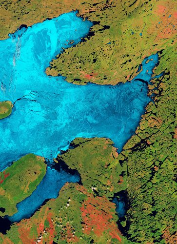
Orbital Surveillance Report
Recent data downlink from the European Space Agency (ESA) provides a high-resolution perspective on Great Bear Lake, located in Canada's Northwest Territories. Positioned on the edge of the Arctic Circle, this expansive body of water remains the largest freshwater lake situated entirely within Canadian territory and ranks as the eighth largest globally.
Geographical and Hydrological Profile
According to ESA, the lake covers approximately 31,000 square kilometers and reaches maximum depths exceeding 440 meters. Its irregular, multi-lobed structure—resembling an amoebic sprawl—is a direct consequence of historical glacial erosion during the Pleistocene epoch. The surrounding terrain is characterized by a mix of boreal forest and tundra, providing a stark contrast to the deep, cold waters that remain ice-covered for up to eight months of the year.
Data from the Copernicus Sentinel missions highlight the lake's role as a critical climate indicator. Because it lies within a region experiencing significant thermal shifts, monitoring the lake's ice-off dates and surface temperature is essential for predictive modeling. The Great Bear Lake watershed remains sparsely populated, with the community of Délı̨nę serving as the primary human outpost, making satellite remote sensing the most viable method for persistent environmental oversight.
Strategic Planetary Monitoring
This imaging reinforces the utility of the Sentinel constellation in tracking sub-Arctic ecosystems. By cataloging the sediment plumes and ice dynamics across the lake's five main arms—Dease, McTavish, McVicar, Keith, and Smith—European agencies continue to provide the datasets necessary to understand the shifting terrestrial cryosphere. Observation protocols remain active.