Sentinel-3 Monitors Anak Krakatau Eruption
Copernicus Sentinel-3 satellites have captured critical imagery of the Anak Krakatau volcanic eruption, providing essential data on ash plume dynamics and regional impact.
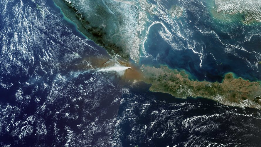
Orbital Surveillance: Sunda Strait
The Sentinel-3 mission, part of the European Copernicus program, has successfully documented the eruptive activity of Anak Krakatau. Located in Indonesia’s Sunda Strait, the volcanic island remains one of the most monitored geological features in the region due to its history of violent activity and potential for triggering local tsunamis.
Data Acquisition
According to ESA, the imagery captured by Sentinel-3 provides high-resolution insights into the scale of the eruption. The satellite’s Sea and Land Surface Temperature Radiometer (SLSTR) and Ocean and Land Colour Instrument (OLCI) allow operators to track the thermal signature of the vent and the dispersion of the resulting ash cloud. These instruments are vital for monitoring atmospheric disruption, which poses significant risks to regional aviation and maritime logistics.
Sentinel-3 Mission Profile
The Sentinel-3 mission is a multi-instrument platform designed to measure sea-surface topography, sea- and land-surface temperature, and ocean- and land-surface colour. By providing consistent, long-term data, it enables researchers to understand global environmental changes. In the context of the Anak Krakatau event, the mission acts as a critical node in Europe’s orbital infrastructure, delivering near real-time data to emergency management services.
As the eruption progresses, ESA’s Earth observation fleet continues to provide the necessary telemetry to map volcanic fallout and structural changes to the island’s caldera.