Orbital Analysis: The Biological Complexity of Roebuck Bay
According to NASA Breaking News, new satellite imaging of Roebuck Bay highlights the critical intersection of tidal dynamics and biodiversity on the coast of Western Australia.
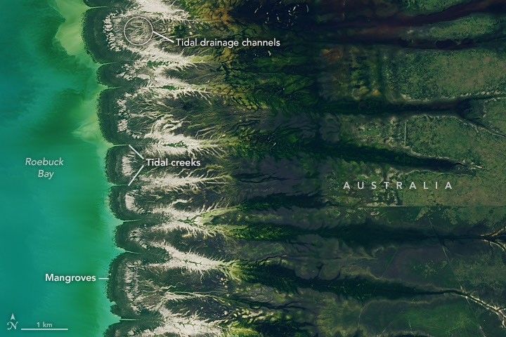
Surveillance Data: Western Australian Coastline
High-resolution imagery captured from orbital platforms reveals the intricate ecological mechanics of Roebuck Bay, located on the northwestern coast of Australia near Broome. According to NASA Breaking News, this region serves as a primary example of high-productivity tidal environments, where the interface of land and sea creates a unique biological engine.
Tidal Dynamics and Substrate Composition
The bay is characterized by its massive tidal range, which can exceed 10 meters. During low-tide cycles, approximately 160 square kilometers of mudflats are exposed. These flats are composed of fine-grained silts and clays, enriched with organic matter. NASA sensors detect significant concentrations of chlorophyll, indicating high densities of benthic microalgae. This primary production forms the foundation of a complex food web that supports one of the highest densities of invertebrates found in any mudflat ecosystem globally.
Avian Migration and Ecological Value
The site is classified as a wetland of international importance under the Ramsar Convention. Orbital tracking and ecological surveys confirm the bay is a critical refueling station for migratory shorebirds utilizing the East Asian-Australasian Flyway. During the peak season, hundreds of thousands of birds descend upon these flats to feed on the abundant polychaete worms and bivalves.
Monitoring these coastal zones from space provides essential data on how changing sea levels and temperatures impact these fragile bio-hubs. For orbital observers, Roebuck Bay remains a high-contrast target illustrating the raw vitality of Earth's intertidal zones.