NASA’s Curiosity Discovers a Field of Martian Polygons
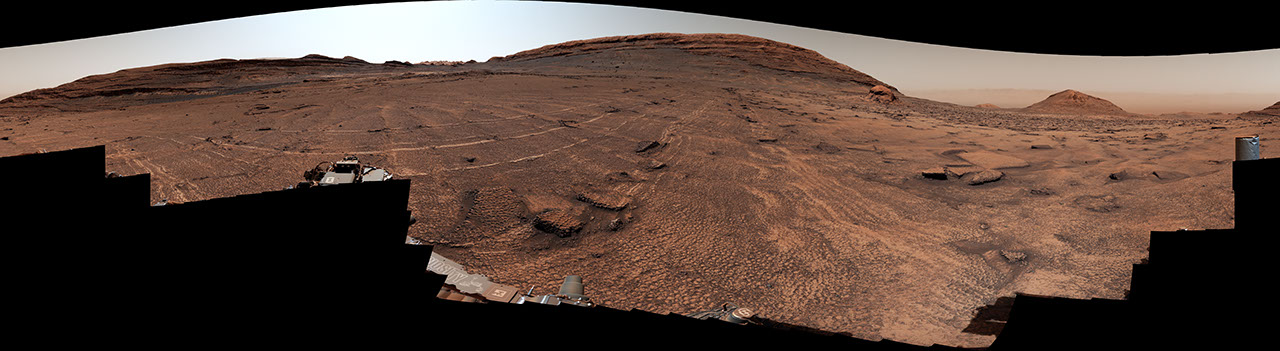
Description NASA’s Curiosity Mars rover captured this 360-degree view of an expanse of terrain covered in surface features called polygons on June 19 and 20, 2026, the 4,930th and 4,931st Martian days, or sols, of the mission. The rover has found polygons several times in the pas
Search
Suggested Searches
- Climate Change
- Artemis
- Expedition 64
- Mars perseverance
- SpaceX Crew-2
- International Space Station
- View All Topics A-Z
- Home
- Missions
- Humans in Space
- Earth
- The Solar System
- The Universe
- Science
- Aeronautics
- Technology
- Learning Resources
- About NASA
- Español
Highlights
  
Back
- Search All NASA Missions
- A to Z List of Missions
- Upcoming Launches and Landings
- Spaceships and Rockets
- Communicating with Missions
- Artemis
- James Webb Space Telescope
- Hubble Space Telescope
- International Space Station
- OSIRIS-REx
- Explore Earth Science
- Climate Change
- Earth, Our Planet
- Earth Science in Action
- Earth Multimedia
- Earth Data
- Earth Science Researchers
- The Sun
- Mercury
- Venus
- Earth
- The Moon
- Mars
- Jupiter
- Saturn
- Uranus
- Neptune
- Pluto & Dwarf Planets
- Asteroids, Comets & Meteors
- The Kuiper Belt
- The Oort Cloud
- Skywatching
- Exoplanets
- The Search for Life in the Universe
- Stars
- Galaxies
- Black Holes
- The Big Bang
- Dark Matter
- Dark Energy
- Earth Science
- Planetary Science
- Astrophysics & Space Science
- The Sun & Heliophysics
- Biological & Physical Sciences
- Lunar Science
- Citizen Science
- Astromaterials
- Aeronautics Research
- Human Space Travel Research
- Science in the Air
- NASA Aircraft
- Flight Innovation
- Supersonic Flight
- Air Traffic Solutions
- Green Aviation Tech
- Drones & You
- Technology Transfer & Spinoffs
- Space Travel Technology
- Technology Living in Space
- Manufacturing and Materials
- Robotics
- Science Instruments
- Computing
- For Kids and Students
- For Educators
- For Colleges and Universities
- For Professionals
- Science for Everyone
- Requests for Exhibits, Artifacts, or Speakers
- STEM Engagement at NASA
- NASA's Impacts
- Centers and Facilities
- Directorates
- Organizations
- People of NASA
- Careers
- Internships
- Our History
- Doing Business with NASA
- Get Involved
- Contact
- NASA+
- Images
- NASA Live
- NASA Apps
- Podcasts
- Image of the Day
- e-Books
- 3D Resources
- Interactives
- STEM Multimedia
- NASA Brand & Usage Guidelines
Highlights
  
Highlights
  
Highlights
  
Highlights
  
Highlights
  
Highlights
  
Highlights
  
Highlights
 [![Request for Information – Potential [Placeholder for Prize]](https://assets.science.nasa.gov/dynamicimage/assets/science/psd/solar/2023/09/s/solarsystem_0.jpg?w=1024)\\
\\
1 min read\\
\\
Request for Information – Potential \[Placeholder for Prize\]\\
\\
article5 days ago](https://science.nasa.gov/technology/workshops/request-for-information-response/) 
Highlights

Highlights
  
Highlights
  
Photojournal Navigation
2 Min Read
# NASA’s Curiosity Discovers a Field of Martian Polygons
PIA26729
Credits: NASA/JPL-Caltech/MSSS
Image Addition Date:07/29/2026
Downloads

NASA’s Curiosity Discovers a Field of Martian Polygons
PNG (305.97 MB)
Download NASA’s Curiosity Discovers a Field of Martian Polygons

PIA26729 Figure A
PNG (3.37 MB)
Description
NASA’s Curiosity Mars rover captured this 360-degree view of an expanse of terrain covered in surface features called polygons on June 19 and 20, 2026, the 4,930th and 4,931st Martian days, or sols, of the mission. The rover has found polygons several times in the past, but never so many in one place. Across the center of this image, the surface is covered by shapes ranging in size from roughly 2 to 4 inches (5 to 10 centimeters) in diameter. The features also surround and wrap around a sand-capped butte nicknamed “Miraflores,” seen at far right in the image.
Figure A
Figure A is a crop from the bottom-center of the panorama highlighting the polygons and their honeycomb-like textures.
Polygonal textures can form from a variety of conditions, including drying out of the surface (like in mud cracks), temperature cycles, compaction after being buried, or shrinkage of the sediment from loss of water or mineral changes. Scientists are measuring characteristics of these polygons to home in on which process formed them.
This panorama was captured by Curiosity’s Mast Camera, or Mastcam, as the rover continued its ascent of the foothills of Mount Sharp, a 3-mile-tall (5-kilometer-tall) mountain that it’s been climbing since 2014.
The panorama is made up of 340 individual images that were sent to Earth and stitched together. The color has been adjusted to match lighting conditions as the human eye would see them on Earth.
Curiosity was built by NASA’s Jet Propulsion Laboratory, which is managed by Caltech in Pasadena, California. JPL leads the mission on behalf of NASA’s Science Mission Directorate in Washington as part of NASA’s Mars Exploration Program portfolio. Malin Space Science Systems in San Diego built and operates Mastcam.
To learn more about Curiosity, visit:
science.nasa.gov/mission/msl-curiosity
Keep Exploring
Discover More Topics From Photojournal
Photojournal\\
\\
 Search Photojournal\\
\\
 Photojournal’s Latest Content\\
\\
 Feedback\\
\\

Δ
Did you find what you were looking for?(Required)
Yes
No
Partly
What were you looking for?(Required)
0 of 1000 max characters
What were you hoping to accomplish by visiting our website?(Required)
0 of 3000 max characters
×
Notifications