GEOSTATIONARY PERSPECTIVE: TOTAL SOLAR ECLIPSE CAPTURED FROM 36,000 KM
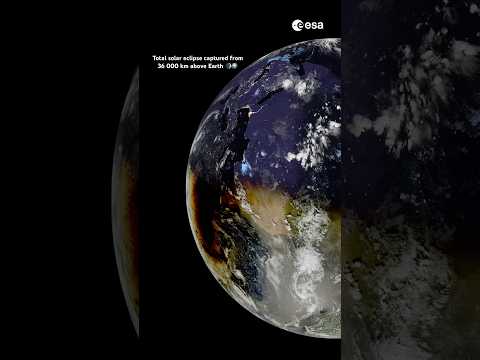
New imaging data from 36,000 kilometers above Earth provides a unique orbital perspective on the moon's shadow transit during a total solar eclipse.
Orbital Surveillance: The Umbra Transit
Data transmitted from geostationary orbit has provided a high-altitude look at the mechanics of a solar eclipse. According to the ESA YouTube channel, imaging assets positioned 36,000 kilometers above the Earth's surface captured the progression of the lunar shadow as it traversed the terrestrial disk. This specific altitude—standard for geostationary meteorological and communication satellites—allows for a constant, wide-angle view of the planet’s hemisphere, offering a perspective impossible to achieve from Low Earth Orbit (LEO) or ground-based stations.
Geometric Alignment
The footage illustrates the precision of orbital mechanics. From this distance, the moon’s umbra appears as a distinct, dark aperture moving across the clouds and oceans. While observers on the ground experience the brief window of totality, the orbital viewpoint highlights the scale of the shadow relative to continental masses. The contrast between the sunlit hemisphere and the localized path of darkness underscores the atmospheric effects and light diffusion at the edges of the shadow's path.
Data Utility
Capturing these events from the 36,000 km mark serves as more than a visual record. It assists in calibrating satellite sensors against extreme changes in light intensity and provides data on how sudden, localized solar shielding affects atmospheric temperature and sensor feedback. The ESA’s documentation of this transit confirms the reliability of high-altitude imaging platforms in monitoring rare celestial alignments and their immediate physical impact on the Earth's illuminated face.