Cryospheric Descent: ESA Tandem Missions Map 30 Years of Antarctic Ice Flux
Data from ERS-1, ERS-2, and Copernicus Sentinel-1 missions have provided a three-decade interferometric record of Antarctic ice shelf instability.
DATA ANALYSIS
New longitudinal studies utilizing data from the European Space Agency (ESA) have provided a definitive 30-year record of Antarctic ice flow. By pairing historical observations from the ERS-1 and ERS-2 missions with current Copernicus Sentinel-1 radar data, researchers have mapped the accelerating degradation of the Southern Continent’s glacial infrastructure.
RADAR INTERFEROMETRY
According to ESA, the process utilizes Synthetic Aperture Radar (SAR) interferometry to detect precise surface displacements. The ERS tandem missions of the 1990s established a baseline by flying satellites in close succession, capturing high-resolution snapshots of ice shelf movement. Modern Sentinel-1 passes allow for a direct comparison, revealing how friction and thermal shifts have altered flow velocities since 1995.
CRITICAL INSTABILITY
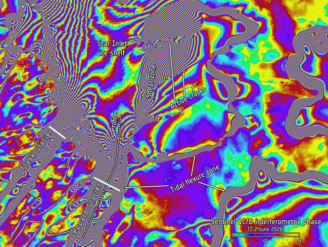
A primary focus of the report is the Scar Inlet Ice Shelf. Data visualizations—known as interferograms—show a stark contrast in the integrity of the ice shelf over the three-decade window. These patterns indicate a significant reduction in the structural resistance provided by ice shelves, which previously acted as "buttresses" to inland glaciers. As these shelves thin or fragment, the discharge of ice into the Southern Ocean increases, directly contributing to global sea-level rise.
MISSION CONTINUITY
The ability to bridge the gap between 20th-century orbital assets and the Sentinel constellation ensures data continuity. ESA officials note that this long-term monitoring is essential for calibrating climate models, as the Antarctic ice sheet contains enough water to raise global sea levels by nearly 60 meters if fully destabilized.